

BY BEN MOKE– COO & MANAGING DIRECTOR (GROUNDPROBE)
The Evolution of Slope Monitoring: From Observation to Intelligent Decision Support
For decades, slope stability management in surface mines has evolved alongside advancements in geotechnical engineering, sensing technologies, and computational intelligence. The journey began with reliance on visual observations and periodic surveying, progressed through the adoption of high-precision monitoring instruments such as Ground-Based Radar/ Slope Stability Radar, and is now entering an era where artificial intelligence, digital twins, and integrated sensing ecosystems are transforming raw monitoring data into real-time operational decisions. The future of slope monitoring is no longer about measuring deformation alone—it is about understanding ground behaviour, predicting evolving risk, and enabling autonomous, and also data-driven decision making that protects people, equipment, and production.
PAST
From Visual Observation to Quantitative Monitoring
For many decades, slope monitoring relied almost entirely on geologists and mining engineers conducting routine visual inspections, mapping cracks, measuring tension fissures, and performing conventional survey observations. While these methods established the foundation of geotechnical monitoring, they were labour-intensive, intermittent, and highly dependent on individual experience. As mining depths increased and slope geometries became steeper, the industry recognised the need for continuous, quantitative monitoring capable of detecting subtle ground movements before catastrophic failure, and this demand ultimately drove the development of high-resolution radar-based deformation monitoring systems in the late 1990s
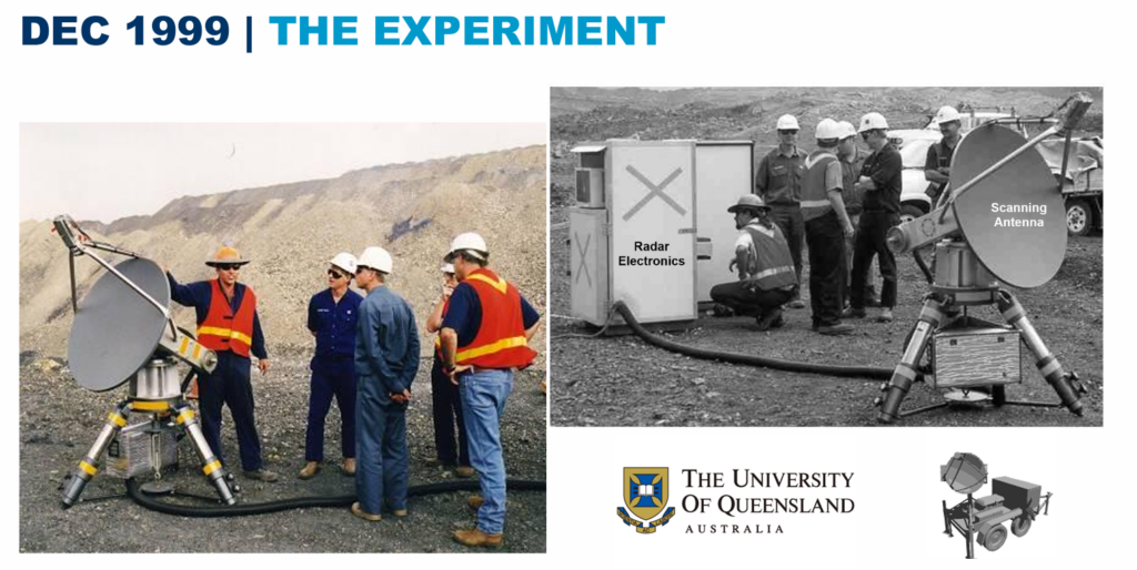
1999 – The Beginning of Radar-Based Slope Monitoring
The first practical deployment of slope stability radar represented a major technological milestone in the mining industry but initially regarded as an experimental technology, radar demonstrated that millimetre-scale surface deformation could be measured continuously over large pit walls without requiring personnel to enter hazardous areas. This breakthrough fundamentally changed the industry’s approach from periodic inspections to continuous geotechnical surveillance.
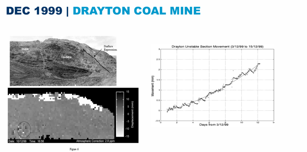
First Operational Deployment
The successful deployment at Drayton Coal Mine demonstrated that radar monitoring could operate reliably under real mining conditions. This marked the transition from research to practical application and established confidence in radar as a valuable geotechnical monitoring tool for operational mines.
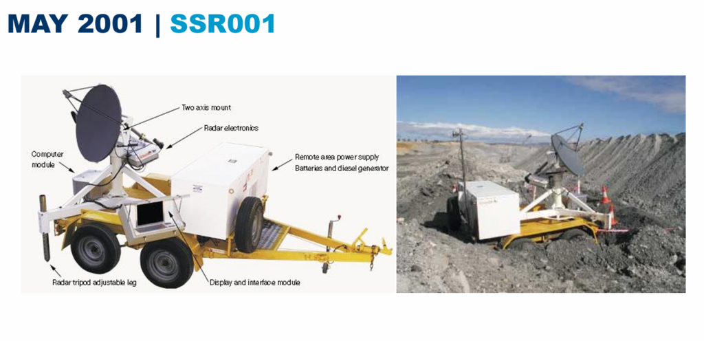
Commercialisation of Slope Stability Radar
The release of the first commercial radar system represented the beginning of a new generation of monitoring technologies. Mines now had access to continuous deformation monitoring capable of providing real-time displacement measurements with unprecedented spatial coverage and accuracy.
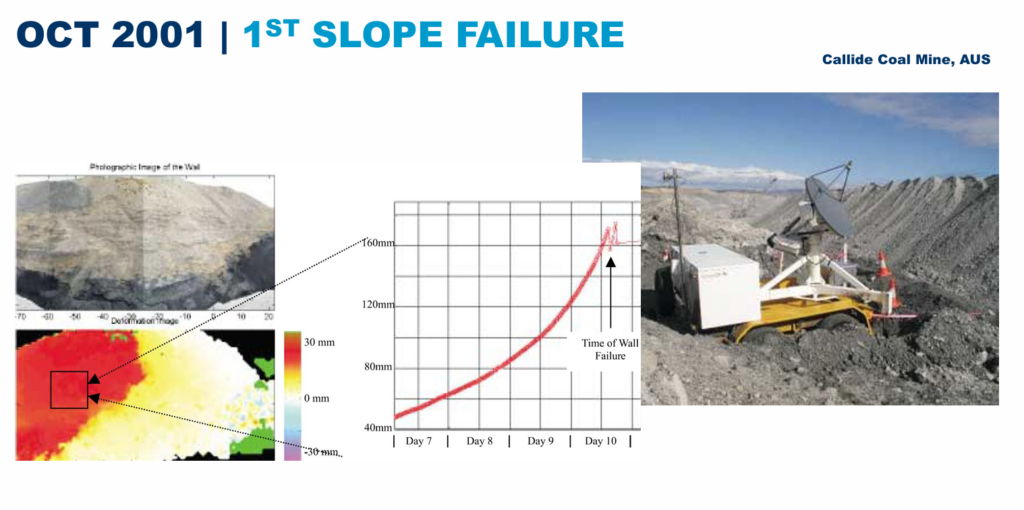
The First Successful Prediction of a Slope Failure
The successful monitoring of the Callide Coal Mine failure demonstrated the practical value of radar technology. More importantly, it proved that continuous deformation monitoring could provide sufficient warning to support safe evacuation and operational decision making before slope collapse. This event significantly accelerated industry confidence in radar-based monitoring.
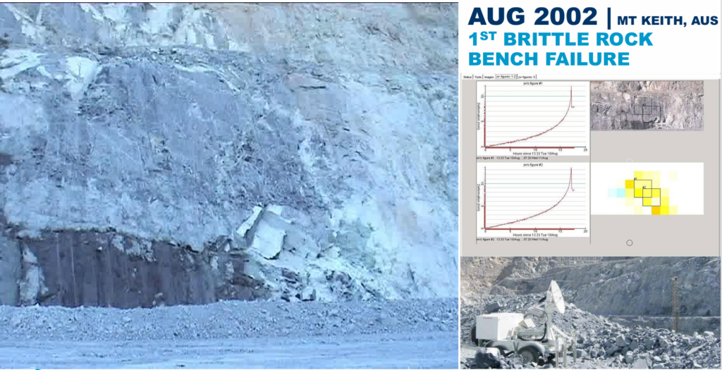
Monitoring Brittle Rock Behaviour
The successful detection of brittle rock bench failure expanded the application of radar beyond large-scale ductile failures. It demonstrated that, under favourable conditions, radar could also identify rapid deformation associated with brittle rock behaviour, opening new possibilities for monitoring high-risk hard rock mines.
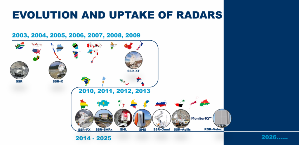
Global Adoption and Technological Evolution
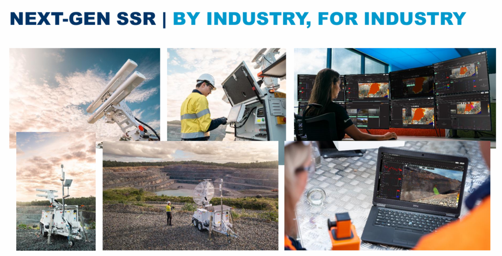
Following its successful implementation, radar technology experienced rapid global adoption. Continuous improvements in scanning speed, spatial resolution, automation, software analytics, portability, and operational reliability transformed radar from a specialised monitoring instrument into a standard component of geotechnical risk management in large surface mines
PRESENT
Today, slope monitoring is no longer viewed simply as measuring deformation. Modern geotechnical practice integrates geological models, structural mapping, hydrogeological information, operational activities, blasting records, and multiple monitoring technologies to develop a comprehensive understanding of slope behaviour. The objective has shifted from collecting displacement data to managing geotechnical risk through timely interpretation, informed decision making, and proactive operational control.
Moving Beyond Monitoring Towards Risk Management
Modern geotechnical monitoring is becoming part of an integrated mining ecosystem where orebody knowledge, blast optimisation, mine planning, and slope stability are interconnected. Data generated from multiple disciplines collectively improve safety, productivity, and operational efficiency rather than functioning as isolated technical systems.
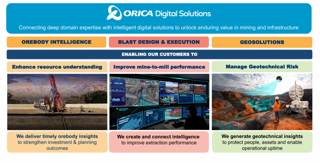
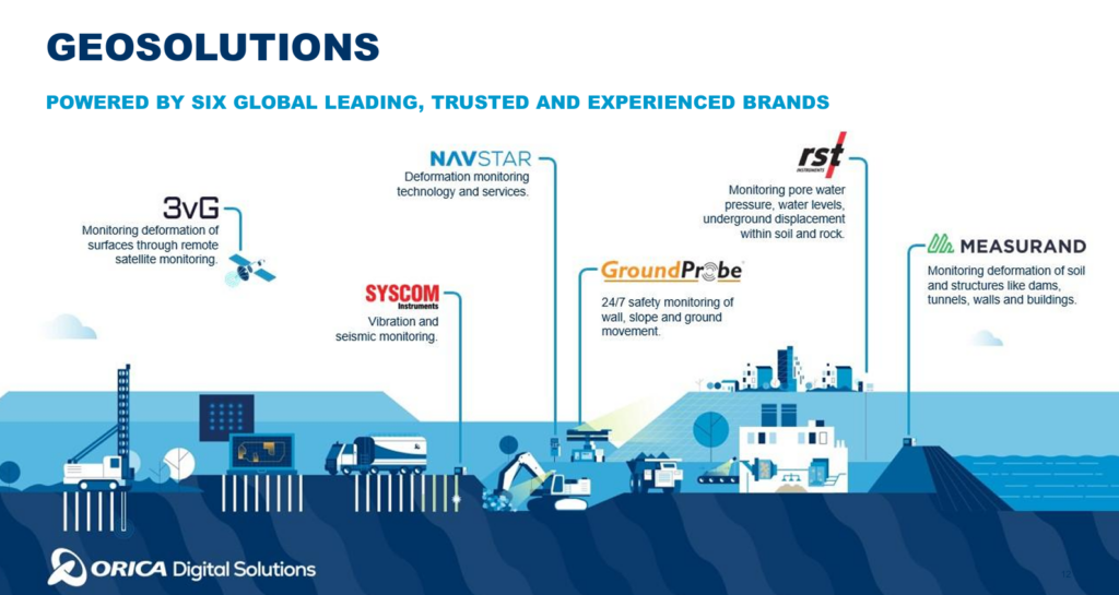
The integration of specialised technologies under a unified geotechnical platform enables seamless data acquisition, interpretation, and operational decision support. Collaboration between different sensing technologies significantly improves the reliability of geotechnical assessments while reducing uncertainty.
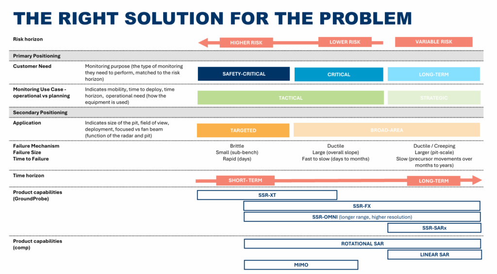
Selecting the Right Monitoring Technology Based on Risk
The future of geotechnical monitoring does not lie in identifying the “best” monitoring instrument but in selecting the most appropriate technology for a specific failure mechanism, operational risk, and required decision horizon. High-risk, rapidly evolving failures require continuous, safety-critical monitoring, whereas long-term strategic planning may benefit from broader, lower-frequency monitoring solutions. Monitoring technologies should therefore be selected based on the expected failure mechanism, deformation characteristics, exposure level, and required response time rather than solely on measurement accuracy or instrument capability.
FUTURE
From Monitoring Ground Movement to Predicting Ground Behaviour
The next generation of slope monitoring will extend far beyond measuring displacement. Artificial intelligence, machine learning, digital twins, cloud computing, autonomous sensing, and integrated operational platforms will continuously analyse geological conditions, deformation trends, blasting activities, groundwater behaviour, weather conditions, and equipment exposure to estimate evolving geotechnical risk in real time. Engineers will increasingly receive actionable recommendations rather than raw monitoring data, enabling faster, safer, and more informed operational decisions.
The future geotechnical monitoring ecosystem will integrate multiple sensing technologies into a single intelligent platform. Rather than analysing deformation independently, future systems will continuously combine radar observations, LiDAR surveys, satellite monitoring, IoT sensors, groundwater instrumentation, geological models, blasting records, and production schedules to create a continuously updated digital representation of the slope. Artificial intelligence will identify abnormal deformation patterns, distinguish genuine instability from environmental noise, explain why alerts have been generated, estimate confidence levels, and recommend appropriate operational actions. Ultimately, geotechnical monitoring will evolve from a passive warning system into an active decision-support framework capable of automatically managing operational risk.
For product details u can visit to the official website of Ground Probe
For more similar articles, this site is the best for you- https://minestronix.com/category/slope-stability/
![]()
Have any thoughts?
Share your reaction or leave a quick response — we’d love to hear what you think!
-
 0
0
-
 0
0
-
 0
0
-
 0
0
-
 0
0
-
 0
0